Friday, May 12, 2006

Hendro's Small Family


This is our small family. It just contains a handsome husband and a beautiful wife. What about the children ? come on mates…we just the new beginning in starting our new family. We still enjoy our togetherness and romantic situations. But we have planned to have children a few years later.

Deep Impact


"Deep Impact" is the one of Hollywood movies tittle. This movie tell about natural disaster that is caused by the earth was hit by meteor fragments. This impact can cause another natural disasters such as earthquake and "big giant" waves (tsunami)

Is it really true that some meteor fragments can hit the earth ? According to "astrophysic teory", planets, stars, commets, meteors have their own orbits. But how come the fragments of meteors can crash the earth ? There were scientific eveidences that the earth was often hit by meteor fragments. Some scientists believe that meteor impact was ended the dynosaurus era.

Shoemaker - Levy is the one of big meteor that have crashed Jupiter. You can imagine if the giant meteor like Shoemaker - Levy crash the earth. What will happen ? NASA indicated that there are big meteor fragments that will pass through near the earth. The meteor name is Schwassmann - Wachmann.

From http://science.nasa.gov/headlines/y2006/24mar_73p.htm I got the information that Astronomer Paul Wiegert at the University of Western Ontario has studied the possibility:
"We believe the cloud is expanding too slowly to reach Earth only eleven years after the break-up," he says, "but it all depends on what caused the comet to fly apart—and that we don't know."
"The most likely explanation is thermal stress, with the icy nucleus cracking like an ice cube dropped into hot soup: the comet broke apart as it approached the Sun after a long sojourn the frigid outer solar system," he explains. "If this is truly what happened, then the debris cloud should be expanding slowly, and there will be no strong meteor shower."

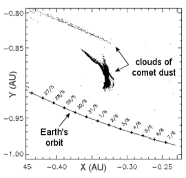
From the picture (download from http://science.nasa.gov/headlines/y2006/24mar_73p.htm), we know that the Schwassmann - Wachmann's orbit is near with earth's orbit in the end of May 2006. The distance is about 0.11 AU. It is quit near if we compare with another meteor that have passed through to the earth.

Some people that believe in UFO and extraterestrial experience claimed that they have got telepathy message from alien. The message containt the information that there will be a big tsunami in 26 May 2006. This tsunami will be caused by Schwassmann - Wachmann meteor crash with the earth.

So, what will we do ? which one of them that we will believe in ? It depends on us. If we just try to make it simple, just forget it. But if we want to think about it clearly, there are many lessons that we can get.

Wednesday, May 10, 2006

Waiting for Letter of Acceptance

What kinds of particular activities that make us bored ? waiting for something is the one of them. Currently, all APS 6M1 are waiting for Letter of Acceptance from universities. So, what will we do during this time ? We will not do anything, just wait and wait. Yeah, thats true, beacause without Letter of Acceptance we can not receive our "lovely" blue passport (for civil servant only). But for some students that have received letter of acceptance (full offer) from universities can continue their preparation before we go to Australia.

I feel little bit worry about this, because if Letter of Acceptance take so long, it will give an "long effect" also in our blue passport. As we know that birocracy in Indonesia is not so good. So, what should we do ? I've contacted the UNSW representative in Indonesia. The thing that makes me happy that my Letter of Acceptance is on its way to me (true or not)

Come on my letter, "come to papa!" I've been waiting for you so long. Please coming quickly, so that I can prepare my study in Australia better.

I've planned to take Master by Research in School of Surveying and Spatial Information System, UNSW. Do you know why that I interest in research ? because I never doing research since I graduated from Department of Geodetic Engineering, Gadjah Mada University. I think this is a great challenge for me to do research in UNSW. But now, during my time in waiting my Letter of Acceptance, I feel so bored. I hope this conditions could not give bad effects in my mind.

Monday, May 08, 2006

System Unification for Geodetic Survey and Cadastral Survey

I. OVERVIEW

Talking about cadastral survey, we always remember about survey for land certificate. This method is used for small area measurement. In Indonesia, cadastral survey identically with no reference measurement. Surveyor can measure every land without geodetic consideration (minimum distance, ellipsoid, datum, reference control point, height and so on)

On the other hand, geodetic survey that is conducted by "science" agency always use geodetic consideration. Reference points, height measurement are the two factors that always follow geodetic survey.

I think this condition is ironic, because they measure the same object but for different purpose. So, what are the disadvantages from this conditions ? There are overlapping work that have been done by different agencies. The second disadvantages is the uselessness of geodetic infrastructures.

So many geodetic infrastructures that have been built by the government become useless because cadastral surveyors do not use these infrastructures. Why they do not use these infrastructures ?

One of the factor that they do not use geodetic infrastructures is that they do not know about the principal of land surveying and mapping. They just know how to measure lands, make a scale and than draw the land. They do not think about the point reference in land surveying and mapping in the good coordinate system.

On the other hand, the most important thing in the cadastral surveying is that the result of survey has to be able to be reconstructed. So, the cadastral result has to containt a good surveying method (using geodetic considerations), a good mapping method (using coordinate system) not just using local system.

Has to be able to be reconstructed itself means that the result of cadastral survey has legal aspect as a proof if someday there will be a land conflict. So, whatever the purpose of cadastral survey (for tax or land certificate), geodetic considerations should be used in every cadastral survey.

II. GEODETIC CONSIDERATIONS

A good survey and mapping has to use geodetic pattern. First of all, before surveyors measure the land, they have to make sure that the land that they will be measured are able to "lay down in the one reference system". It means that all land that have measured must be integrated in the one coordinate system.

If the land or area does not have reference points, surveyor has to make reference points first. For good surveying, it must be 2 reference points for minimum constraint. These reference points have function as a reference for surveyor to do survey. Reference here means that these reference points already have coordinate in global system.

Cadastral survey always use assumption that the earth is flat. This assumption is totally wrong. Earth is not flat. In some particular distance (111 km), the around effect of the earth has to be considerated in coordinate computation. So, if the area of measurement is more than 111 km, the coordinate computation has to used geodetic consideration.

In this particular thing (geodetic consideration), geodetic distance, geodetic lines, projection system are the most common computation in determining coordinate. But commonly, cadastral activities do not use these.

Friday, May 05, 2006

The Beginning of The New Journey

This morning, we have received our IELTS score. Lucky you Hendro, you got 6.5. What does it mean? It means that you already have completed your EAP course? It means that you will be accepted in School of Surveying and Spatial Information System, UNSW? Please do not be happy with this result. It is the starting point when you will continue your study in Australia. You will see another view in Australia, a lot may be. Please be prepare that you will compete with another international students, Australian students. You will see many Indonesians, many Australians also (good and bad), but the important thing that you have to adapt with Australian culture quickly. It will influence your study in the future.

Thanks to all APS 6M1 students, you are very nice persons dudes. Keep in touch yaah...see you in Australia...

For my wife, thanks for everything. Without your support, I can do the best. But please join me in Australia if you take a long vacations. Love so much sweet heart.

Monday, May 01, 2006

NEW INFRASTRUCTURES FOR REGISTERING 3D PROPERTIES*

Keywords : parcels, cadastral surveying, 3D properties, underground constructions, overhanging constructions

Abstract
Marine cadastral and registering 3D properties become hot issues in land registration problems. In this paper, I will figure out the approach for registering 3D properties. This approach, that has been used in Norway, is the new infrastructures that will support registering 3D properties in Indonesia. The infrastructures consist of technical aspect and law aspect (bill and regulation). Technical aspect contains about cadastral surveying for 3D properties and making 3D mapping. Law aspect contains about regulation and bill that arrange 3D properties. These new infrastructures are important for supporting in registering 3D properties.

I. Background

Indonesia has approximately 80,000,000 parcels in productive areas. The number of parcel that has been registered is approximately 20,000,000 parcels. So, we have approximately 60,000,000 parcels that have not been registered yet. We have all infrastructures for registering these parcels. These parcels are registered in 2 dimensional forms. Meanwhile we have not finished yet in registering 2 dimensional (2D) properties, new problem in registering 3 dimensional (3D) properties comes up.
New inventions in science and technology have allowed people to make underground constructions. Underground constructions usually have a strong relation with the availability of underground map and 3D maps (Valstad, 2001). The other problems come up related with land registration for underground parcels. It was too difficult to determine the title and the owner of underground parcels, because these parcels still have strong relation in law with the parcels above. New inventions in science and technology also allowed people to make overhanging constructions. The same with underground constructions, it is difficult to identify the rights in overhanging constructions.

II. 3D Properties

These constructions, overhanging and underground, can be definite as 3D properties. It means that these properties not just land that has 2D (length and wide), but they also include the properties (building, house, etc) that attach with the land. So, it must have 3D (length, wide, depth / height). Van Oosteroom (2003) stated that there are a number of factors which can accelerate the growing interest for 3D properties :
1. A considerable in private property value;
2. The number of underground, overhanging constructions and multilevel buildings has grown considerably in the last forty years;
3. An upcoming 3D approach in other domains.

III. Cadastral and Land Registration

Cadastral, according to Asoegwu (2000), is a complete up to date official record or inventory of land parcels within an area administered by a government unit. Land registration include in cadastral process. In Indonesia, Agrarian Law 1960 plays important role in land registration. Agrarian Law mentions that the freehold title is the strongest right which people can hold. If someone has freehold title, he or she can do everything with his or her land. He or she also owns all area, above and below, of his or her land. It means that all natural resources below and above the land also belong to the owner of the land.
This condition caused difficulties in registering 3D properties. Stoter and Ploeger (2003) stated that current cadastral registration systems, based on 2D for describing parcels, have shown limitations in providing insight in (2D and 3D) location of 3D constructions (e.g. pipelines, tunnels, multi level buildings) and in vertical dimension (depth and height) of established for 3D constructions.

IV. Practical Approach for Registering 3D Properties

Until today most countries have developed their own cadastral system, because there are supposed to be huge differences between different systems (Van Oosteroom, 2003). According to Bogaerts and Zevenbergen (2001), some of those systems are based on general boundaries approach, others and fixed boundaries. Indonesia uses general boundaries approach and “contradicture – delimitation” as basic approach for boundaries agreement.
Indonesia condition is similar with Norway in registering 2D properties and boundaries approach. But for registering 3D properties, there is something interesting in the way Norway started registering 3D properties. Oslo’s local government just realized that it was very important since they built “the city’s first underground train way”. So, it can be compared with our condition right now that the government started to build mass transportation based on monorail mode and underground railway mode.
The first thing that the government should do is making parcel – based land information system. National and Local Government have to have regulations that all parcels have to be connected with their spatial information and its property.
The second thing is providing the availability of accurate 3D registration maps. 3D maps is very important for registering 3D properties, because 3D maps are used as archives for 3D properties.
The third thing is making the suitable regulation for 3D properties. Agrarian Law 1960 needs to be revised. Amsterdams Arena Football Stadium in Amsterdams could be a good example. There are an underground railway station, car parks and malls below the stadium. Amsterdams’ local government made special regulations on this building and spent many years in development studies before they built this building. It also happens in Indonesia, when Jakarta’s local government wants to build Monorail. Even though the Monorail is still under construction, we haven’t heard yet about the regulations.

V. Conclusions

This approach could be definite as technical aspect and law aspect. Technical aspect itself could not work out without support from law aspect. It also happens with law aspect which could not work without using new technical aspect. Although 3D properties are not common in Indonesia, we have to prepare for these. Slowly but sure, 3D properties will become a trend in Indonesia. Monorail and underground railway could be a starting point in 3D properties development.


REFRENCES

Asoegwu, R.N. (2000) On The Concept of Multipurpose Cadastre, Seminar / Workshop On Functional Multipurpose Cadastre for National Development. NIS, Enugu Branch.

Bogaerts, T. and Zevenbergen, J. (2001) Cadastral Systems in Alternative, in Computers, Environment and Urban Systems, Theme Issues Cadastral Systems, p. 325 – 337, Volume 25, numbr 4 – 5, 2001, Elsevier Science, New York.

Osteroom, van, (2005) Impact Analysis of Recent Geo – ICT Developments on Cadastral Systems, FIG XII International Congress, Washington.

Valstad, T. (2003) The Oslo Method – A Practical Approach to Register 3D Properties, FIG Working Week, Paris.


Monday, April 03, 2006

Cartoons and Democracy

“Is making insulting cartoon a part of freedom in democracy? “

Drawing cartoon for expressing the idea is all right for several people that love painting and drawing. But if the cartoons are used for some particular reasons that can make other people or nation angry, is it still a kind of freedom in democracy?

Last year, Danish’s newspaper made cartoons that insulting Prophet Muhammad. Then, most of Moslems in the world protested this action. In some countries, many riots happened because of these cartoons. The Moslems believe that Muhammad is holy prophet that every person has to respect whatever their religion. On the other hand, the newspaper claimed that it was a part of freedom to express their opinions.

This claim was also used by some Indonesian and Australian journalists. Firstly, Indonesian journalist, in Rakyat Merdeka newspaper, made the cartoon that insulting Australian Prime Minister (John Howard) and Australian Foreign Minister (Alexander Downer). On this cartoon, they described that two Australian politicians like Dingo (Australian native animal). They acted like a dog and having sex above Papua Island. Secondly, a few days after this cartoon has been published, Australian journalist also made a cartoon that insulting Indonesian President (SBY). On this picture, they described SBY like a dog and having sex with Papuanese.

Overall, people in every country do not like these cartoons. These cartoons are very obnoxious. So, by doing activities that insulting people or nation are a part of freedom in democracy? I do not think so. Democracy has a great value in respecting other people and people’s opinion. There is an important value that most people forget about it. Democracy will appreciate with people’s opinion but it will be more appreciate with people who can express their opinions without insulting or disturbing the others.

Monday, March 27, 2006

Research Proposal

IMPLEMENTING GPS FOR CADASTRAL SURVEYING
AND ALTERNATIVE SOLUTIONS

The Global Positioning System (GPS) was designed and developed by the US Department of Defense (US DoD) primarily for navigation purposes giving positions in real time to around 5 – 20 cm accuracy (Roberts, 2005). On one hand, using GPS offer many advantages for surveying activities. On the other hand, GPS cannot be used in the specific area that has unclear sky view. The other problem, using GPS for cadastral surveying, is coordinate system. It is important to set a standard by providing the public and private agencies with uniformity to aid in communication and to limit confusion (Dalager, 2002).

Nowadays, cadastral surveying is facing big challenge. The main challenge is how can cadastral surveying provide the accurate data and up to date data. In Land Registration, the accuracy is the main point. Because the data are highly related with determine of law status and right title of the land. Londe (2002) stated that the adoption of high production GPS techniques is changing how large scale cadastral surveying are performed.

The objective of this research is to combine the different ways of using GPS for cadastral surveying and its implementation in accuracy. In particular, the research sets out :
1. Implementing Real Time Kinematics method for cadastral surveying.
2. Implementing another source of waves to improve Real Time Kinematics method.
3. Compare GPS Surveying with Total Station Surveying.
4. Network design management.

This research hopes to provide a good analytical consideration for using GPS in cadastral surveying. In the future, maybe it will be the recommendation to what extend that GPS can use for cadastral surveying.

REFRENCES

Dalager, B. (2002) Developing and Implementing a Large Scale Cadastral Resurvey with GPS, FIG XII International Congress, Washington.

Londe, D. M. (2002) Standards and Guidelines for Cadastral Surveys Using Global Positioning Methods, FIG XII International Congress, Washington.

Roberts, C. (2005) GPS for Cadastral Surveying – Practical Considerations, Proceeding of SSC 2005 Spatial Intelligence, Innovation and Praxis : The National Biennial Conference of the Spatial Science Institute, Melbourne.

Critical Review

Tor Valstad in the first part of his article “The Oslo Method – A Practical Approach to Register 3D Properties” gave a brief explanation about regulations and methods to register 3D properties. The Planning and Building Authority is the board that has the task of combining building control, planning, surveying, and land registration since 1992 in Norway. Oslo’s local government gives right to property developers to make all local development plans. The problem came up when the property developers made development plans below the ground.

This problem has a strong relation with the availability of underground map (3D map). For 2D map, Oslo has a good system in digital mapping. All of Oslo’s areas are covered by base maps in 1:500 and 1:1,000. Regularly, the maps are up dated every 3 years with photogrammetric mapping. But for 3D mapping, Oslo’s local government just realized that it was very important since they built “the city’s first underground train way”.

When the local government allowed property developers to develop underground constructions, another problem came up. The problem was about land registration and cadastral system that will be used in these properties. It was too difficult to determine the title and the owner of underground parcel, because this parcel still has a strong relation in law with the parcel above.

In the other parts of his article, he gave an explanation about cadastral system in Norway. The system “is a parcel – based land information system”. National and Local Government had regulations that all parcels had to be connected with their spatial information and its property. In parcel identification, Norway has a unique system. Every parcel is given the name in the digital format. The number contains 12 digits. 4 digits are to identify the municipality and 8 digits to identify the parcel’s number. This system also will be used in underground parcels.

In the last part of his article, he gave a practical approach to overcome the problems. For cadastral surveying, surveyors in Norway are allowed to use sophisticated tools like Reflectorless and Total Station. Then, for 3D mapping they use 3D coordinate system. Besides measuring 2D aspects (X,Y) surveyors also measure height to get 3D system (X,Y,Z). But these methods still need some studies for testing the effectiveness of these methods, because it is not easy to make underground maps and do underground construction. Related with law aspect, some regulations from The Government should be released to support technical aspects.

The same as our problems here, we find many difficulties to overcome in registering 3D properties. The first problem is the availability of accurate 3D registration maps. I think it is very difficult and needs a long time to do this. The second problem is the suitable regulation for 3D properties. Amsterdams Arena Football Stadium in Amsterdams could be a good example. There are an underground railway station, car parks and malls below the stadium. Amsterdams’ local government made special regulations on this building and spent many years in development studies before they built this building. It also happens in Indonesia, when Jakarta’s local government wants to build Monorail. Even though the Monorail is still under construction, we haven’t heard yet about the regulations.

In practical approach about these problems, I truly agree with Tor. 3D coordinate system has to be used in order to make 3D map. Because in the future, we have to transfer this system into 3D Land Information System. The other advantage in using 3D coordinate system is to coordinate transformation. Because if we have already used 3D coordinate system, it is easy to transform the coordinate into global system.

For using sophisticated tools in measuring underground constructions like Total Station, Reflectorless, I think it is a must, because it is quit different if we do land surveying and underground surveying. Especially in cadastral surveying, good accuracy in measuring land is a must. So, to do underground surveying of areas with a lot of disturbances, and had to use sophisticated tools. The other sophisticated tool that we have to use is Global Positioning System (GPS). This instrument is very helpful, because we have to make a coordinate reference system in the ground if we want to do underground mapping. Besides using sophisticated tools, I think The Planning and Building Authority should use standards of accuracy in every land measurement.

Overall, I like all of the ideas from this article. Tor gives me another perspective to approach how to register 3D properties. But the most important things that he stated were the parcel identification and making database system in land registration, although he was still confused as to which one to do first, the 3D construction and 3D mapping or making 2D and 3D database.

Building a database system and making 3D maps have to be done together. But I think these actions should be followed with strong regulations from government. Yes, we commonly know that land conflict always comes up from unclear rules and mistakes in conducting data from surveyors. But we can handle it with strong regulations and good technical aspects.

IELTS Test

We have done the best for IELTS Test in 22 April 2006 ....
The result will be announced in 5 May 2006. I feel so nervous ....